People on the ground
Photos, video and location from residents, field crews and contractors. Request the missing observation through a browser link.

Platform
FAQVisual Data EngineAI & SearchEnterprise TechnologyProductsAwarenessCrowdsourceAnalyticsSmart SearchTrust EngineKuntapalveluDokumenttihakuLuontotietoCrowdsource Product TourPricingCrowdsourceKuntapalveluOther products – request a quoteIndustries
Sports Teams & FederationsEvents & Corporate ExperiencesAssociations & Member OrganizationsPublic SafetyCasinos & VenuesMedia & NewsroomsEnterprise MarketingCustomer StoriesCompany
AboutTeamPartnersContactNewsInvestorsAn outage on one screen. A road incident on another. A resident’s photo in an inbox.
Awareness brings observations, public information and your city’s connected systems into a shared view—so your team can understand what needs attention and decide what to do next.
Built by BCaster. For everyday operations and disruption response.
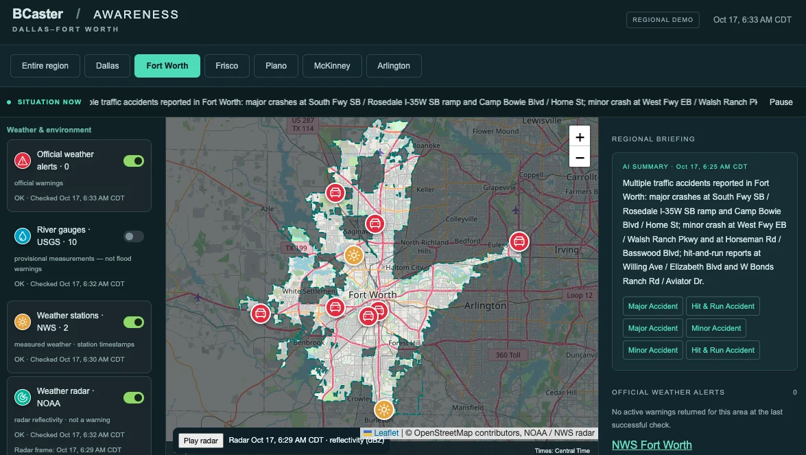
6 city views + the regionDallas · Fort Worth · Plano · Frisco · McKinney · Arlington
Sources you can inspectOpen the records behind a briefing. Check location, update time and availability.
A starting point for your citySelected public feeds demonstrate the approach. Your operational data is connected during deployment.
The demo presents selected public sources, including weather, traffic and Oncor outage data, where available. Briefings depend on fresh, usable records for the selected area. Coverage differs between cities; some feeds may be unavailable or require separate access. It is a presentation environment, not a complete city monitoring service.
Resident reporting, internal system integrations and operational workflows are scoped separately for a customer deployment. The customer arranges any required data-provider agreements; BCaster implements the agreed integrations.
A map gives the situation a location. A photo from the scene gives it context. Awareness connects both to the people responsible for the next step.
Photos, video and location from residents, field crews and contractors. Request the missing observation through a browser link.
Weather warnings, traffic incidents, utility outage reports and other available feeds, with their timestamps and coverage limits.
Connect agreed camera, sensor, water, electricity, communications and maintenance data through available interfaces.
A photo, video, alert or measurement arrives with its available context.
AI helps summarize the information. Your team checks the sources and uncertainties.
Use the shared view to prepare the next action and connect it to an agreed workflow.
Ask someone on site for the information your systems cannot provide.
A targeted capture link lets staff, contractors or residents contribute photos and video without installing an app. Agree who receives requests, how observations are reviewed and which information may be shared.
AI supports the review. Source material and uncertainty stay available, and the responsible person decides what happens next.
Bring a reported road defect, its location and a field photo into one review. Prepare the right crew and equipment. Scope repair confirmation and before-and-after evidence into the workflow.
Measure: handling time, clarification requests and repeat visits.
View agreed water, electricity and communications information alongside access constraints and local observations. Identify what needs checking without assuming that nearby events share a cause.
Measure: time to understand an incident and reach the responsible team.
Use weather warnings, outage reports and safely gathered field observations to support a shared briefing. Practice the same observation and review process before a disruption occurs.
Measure: time to a reviewed briefing and usefulness of field observations.
Start with a defined information need and the sources that can answer it.
We map the available interfaces, source permissions and operational responsibilities with your team. The delivery scope defines integrations, AI processing, access, retention and deployment requirements.
Cloud, private-cloud and on-premises options can be evaluated against your requirements. The architecture and supported functionality are agreed during scoping.
Give staff and approved partners access to the information needed for their responsibilities.
Scope a resident-facing map or reporting page for your website. Publish only the information your city approves.
Your city retains its data-provider relationships. BCaster connects the agreed sources and tests the implementation with your team.
Choose a real operational question. Demonstrate the workflow with your team, then evaluate the value before expanding.
Bring operations, public works or emergency management together with IT and the relevant data owners.
Discuss a pilot →The starting point is to connect relevant information from your existing systems. Any write-back, work-order routing or replacement functionality is agreed explicitly as part of the delivery scope.
Yes. A pilot can begin with internal staff or selected contractors and one operational use case. A public reporting channel can be considered separately.
No. It demonstrates a map-based view and source-linked briefings using selected public data. Customer-specific integrations, observation workflows, access controls and deployment requirements are defined and tested separately.
A proposal is based on the agreed scope: integrations, users, data and media volumes, AI processing, deployment and support. The first discussion defines a suitable pilot rather than assuming a one-size-fits-all city rollout.
Bring a real example to the conversation. We’ll use the demo to explore the workflow and define a focused next step.
Working with Locktera? Ask your Locktera representative to coordinate an Awareness walkthrough and pilot discussion with BCaster.
Janne NeuvonenFounder & CEO · BCasterjanne@bcaster.com
Petri LaitinenCOO · BCasterpetri@bcaster.com